
There are additional point details that can be added and edited on the individual points. Right click a map point to bring up an edit window. The point on the map “bounces” while the edit window is open to indicate which point is being edited.
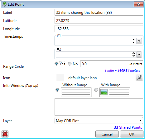
The dialog shows the point label, latitude, and longitude. The start and end timestamps can be edited by clicking the drop down calendar. A range circle can be drawn around the point in meters. The icon for that point can be changed by clicking the icon button and selecting from the stored icons on the system.

An info text window can be created with or without an image file by entering text and selecting with or without the image file. If an image file is desired, click the browse button and navigate to the image file to include. The image file is automatically scaled down.

The last selection in the dialog is which layer to save the point and the changes into.
When multiple points share a location there is a link to the other points that share that location. This occurs when a tower plot or CDR plot has multiple references to that single tower or GPS location. Double click the link to bring up the list of the multiple points sorted by timestamp.

Click OK to go back to the editing screen and click Apply Now to display the data on the screen.

Click the edited point to see the pop out note with image.
